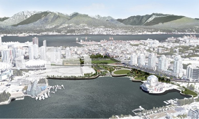
The City of Vancouver and the Vancouver Park Board have released a draft map for the future of False Creek, with over 14 acres of park planned for the northeast area and a new street network to replace the existing viaduct.
City councillors voted to demolish the Georgia Viaduct — which connects easterly neighbourhoods to the downtown core — nearly two years ago.
Officials said the spans would be replaced with a sprawling, ground-level road network with green space to fill the gaps. The plan is expected to cost around $200 million.
In theory, two-way traffic would be diverted along a new Pacific Boulevard, avoiding the traffic bottlenecks common on the viaduct.
The proposed roadway has fewer lanes than the existing overpasses, but city officials said that doesn't mean they won't be able to handle the workload.
"It's important to remember that the viaducts only carry about 40 per cent of the capacity they're designed for [each year], so the new network will be more than able to carry all the traffic for the future area," said project director Kevin McNaney, who told CBC he's spent six years looking through technical studies to ensure the roads will be adequate.
The plan's early draft, unveiled Monday, includes:
14.3 acres of park space (worth around $20 million).
A new skate park.
A waterfront pavillion.
Gardens.
Waterpark.
Playground.
Elevated walkway.
Two new city blocks would also host market and social housing units. The city said it expects the area will be home to up to 12,000 new residents by 2025.
There are also plans for a walkway along Dunsmuir Street up the 15-metre-grade into Vancouver and an interconnected park designed by James Corner, creator of the High Line Park in New York City.
The viaduct was originally built as part of a proposed larger freeway through East Vancouver in 1971, but plans for a bigger road were tossed as residents protested.
Currently, the city says six per cent of commuter traffic travelling in and out of the downtown core uses the twin spans.
The full draft plan and concept design for the new park will be available to the public at an open house to be held on Carrall Street between Keefer Street and Expo Boulevard on Saturday.
Residents will be able to provide feedback at that event, which will be relayed to council.
Construction on the project is expected to begin before year's end.